Once all the fuzzy images and weighted factors have been determined, they are ready to be aggregated. In this section of the spatial analysis, the MCE - Weighted Linear Combination is used. When the WLC was used, each standard factor has been multiplied by its corresponding weight. These were then summed, and then the sum was divided by the number of factors (which is 5 in this case). Once the weighted average has been calculated for each pixel, the resultant image was multiplied by the relevant Boolean constraints (WATERCON.rst and LANDCON.rst) to mask out areas that should be not considered for Urban development at all. The final image produced below is a measure of aggregate suitability index that ranges from 0 to 255 for non-constrained locations.
Please see Methodology for a more in depth description of this procedure used in generate a final image
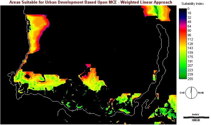
According to the image below, areas indicated in black shows areas that not suitable for urban development at all. While areas indicated in blue/red shows areas of low suitability for Urban development. Areas indicated in yellow/green shows areas that are high in potential suitability for urban development. As expected, areas that are considered suitable for urban development compared to the LANDCON.rst image. However, the WLC identified more areas for Urban development compared to the final map of the Boolean Overlay approach.
The following resultant image is the result of using WLC - MCEWEIGHT.rst
Result Assessment/Comment of the MCE - Weighted Linear Combination:
This is a simple Urban Development Suitability Model based 2 constraints, and 5 factors. Its intention to indicate generally, the optimal scale of potential urban development in the North Shore Mountains region in the near future. It will also give us a general idea about the suitability for potential urban development at every location/site in the North Shore Mountains area. However, there is a difference between suitability and predictability displayed in this project. While it is one of the primary objectives of this model (to determine areas of potential urban development), this model does not necessary show optimal locations for urban development. Other factors such as property taxes, land availability, community attitudes toward development, etc., would likely assert a significant effect on which lands will be eventually be developed.
Another point wroth mentioning is that the WLC procedure allows the full tradeoff among all factors. The amount any single factor was compensated for another is, however , was determined by its factor weight. In this project, a high suitability score in SLOPEFUZZ2.rst easily compensated for a low suitably in FOREST_PARKFUZZ.rst for the same given location, resulting that given location had a high suitability score. In the reverse scenario, a high suitability score in FOREST_PARKFUZZ.rst only weakly compensated for a low scare in SLOPEFUZZ2.rst. It can trade off, but the degree to which it will impact the final results is severely limited by the low factor weight of FOREST_PARKFUZZ.rst (0.00769 compared with 0.3316 in SLOPEFUZZ2.rst).
Special Note:
Due to the limited resolution of this computer monitor, these areas
may or may not coincide with what is indicated by this model.
Go to Methodological
and Operational Problems/Conclusion (5.0)
Or click here to go back to main menu